Tsum Valley Trek
The Tsum valley trekking is one of the distant and ...
In the far western region of Nepal, the Himalayan lands of Dolpo have always been a fascination for adventurers and trekkers alike. Along with the unique and vibrant culture of the locals, the Lower Dolpo Trek is a perfect mix of adventure and thrill. Stretching through the mountain passes of Numa La (5308m) and Bagala La (5169m), the journey explores the off-beat trails. Similarly, the Bon Po culture, Phoksundo Lake, and the Shey Phoksundo National Park are few of the attractions on the Lower Dolpo Trek.
The Lower Dolpo Trek begins with a pleasant flight from Kathmandu over to the Terai city of Nepalgunj. Another flight from Nepalgunj takes the trekkers to the trail-head located at Juphal. Gradually ascending through the hilly trails, the journey takes us to Dunai for our first night on the go. The trek continues on towards Tarakot as we follow the Thuli Bheri River. As the valley gradually opens ahead of us, we head over to Laina Odar. Continuing towards Dho Tarap, we cross the hamlet of Nawarpani en route. We take a day off at Dho Tarap for acclimatization and prepare to make our way over to the first mountain pass of the journey. A difficult ascent brings us to the top of the Numa La Pass (5,308m), where the vistas of the surrounding landscape and looming Himalayas offer a blissful stop. Then, we head over to Danigar where another mountain pass awaits. Crossing Bagala La (5,169m), the journey once again ascends towards Temche before turning towards Phoksundo Lake. Enjoying the majestic views of the Himalayas and the tranquil lake, we make our way down towards Chhepka before heading back to Juphal. Flying back to Nepalgunj and then to the capital-Kathmandu, brings our adventure to a close.
We, here at Cold Feet Adventure, have been accompanying trekkers in every way of the Himalayas. With well-trained guides and inclusive itineraries, we assure you an unforgettable adventure through the Himalayas. We also have a number of different adventures around the country all designed to quench your thirst for adventure.
Landing at the Tribhuvan International Airport, a company representative will receive you and take you to the hotel in the city. Upon reaching the hotel, you can rest and relax. You can also choose to explore the nearby sites that gather interest from the tourists.
In the initial half of the day, we gather all the permits necessary for trekking in the Dolpo region. Making sure we are ready to we board on the flight heading towards Nepalgunj. The 40-minute flight takes us through contrasting landscapes heading away from the high hills of the valley to the flatlands of Terai.
An early day as we make our way out of Nepalgunj flying over to Juphal. In the company of the hilly landscapes, we begin our trek. Gradually descending from Juphal, we take the company of the Thuli Bheri River. Past the terraced farmlands, the journey passes numerous settlements including Rupgad and Dhupi Chaur. Continuing on the trail, we reach Dunai.
The day is a pleasant one as we begin our journey crossing several streams to meet the Bheri River. Through the lush green forests adorned with pine and fir trees, the trail continues to follow the Bheri and Bharbung River heading towards Tarakot. Once a capital city of an ancient kingdom, Tarakot, today, is known after the local fortress built during the ancient times.
Today, we make our way towards the hamlet of Laina Odar crossing the 3,000m altitude mark. Exiting Tarakot, the trail heads towards the confluence of Bharbung Khola and Tarap Chu River. Beyond the confluence point lies the ancient Chhedhul Gompa which was built during the 11th century. Taking some time off to explore the monastery, we make our way towards Laina Odar.
An early day as we make our way towards Toltol heading past the hamlet of Nawarpani en route. Exiting Laina Odar, the journey once again finds the forested lands ascending through the opening valley. Entering isolated trails, the journey ascends through the steep rugged trails accompanied by the Tarap Chu River. Taking a brief rest at Nawarpani, we make our way towards Toltol.
Continuing our strenuous ascending route, the trail brings us to Ghyamgar at the bank of the Tarap River. Continuing we reach the Langa Camp at the confluence of Tarap Chu River and Klang Khola. Heading into the Himalayan valley, the journey soon leaves behind the lush green forest heading above the tree lines to meet the alpine shrubs. Through the arid Himalayan terrain, we make our way towards Dho Tarap.
The very first of our acclimatization days we take some time off at the hamlet of Dho Tarap. Here, we can enjoy the local culture and way of life. For our acclimatization hike, we make our way towards the surrounding Buddhist as well as Bon Po gompas. Home to both Nyingmpa sect under Buddhism as well as Bon Po followers, the hamlet also provides for a fresh look at the culture and religions prevalent within the region.
Making our way deeper into the Himalayas, the journey today begins away from Dho Tarap and towards the Numa La Base Camp. Following the Tarap Chu River upwards, the trail continues to ascend through the plain valley towards the Tokyo village. Here, we can also visit a monastery for the Chiba group. Taking some time off to rest and explore, we continue our journey through the rugged Himalayan trail and over to the Numa La Base Camp.
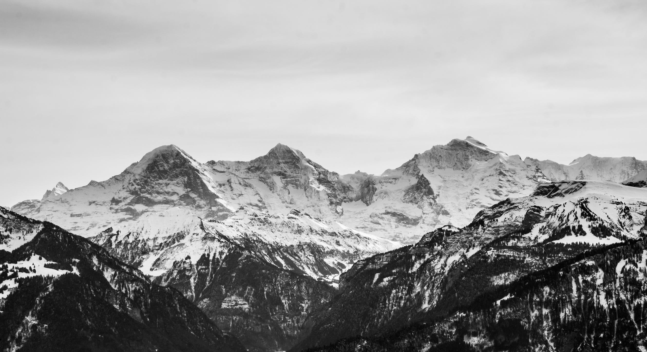
The very first of our mountain pass on this trip, the trail takes us to the top of Numa La Pass. At an altitude of 5,308m, the mountain pass boasts stunning views of the entire Dhaulagiri Range including the majestic Dhaulagiri (8,167m). The journey atop the summit of Numa La is an ascending route through the snowy trails all the way to the ridgeline leading to the top. After some time, we descend to Danigar located at the bank of the Panklanga River.
The second and final one of our mountain passes today we make our way over to Temche crossing the Bagala La Pass en route. Setting off on the ascending route, we navigate past the snowy trails to make our way atop the Bagala La Pass. At an altitude of 5,169m, the mountain pass offers stunning views of the entire Kanjirowa Himalayan Range and the Phoksundo Lake. Enjoying the pleasant views, we make our way over to Temche.
Continuing our ascent from Temche, we reach Yak Kharka which marks the beginning of our descending route. Welcoming back the tree-line, the hilly trail gradually makes it's way away from the Himalayas and towards the lush green forests. Enjoying the pleasant shade offered by the pine and fir trees we make our way over to Phoksundo Lake crossing Ringmo Village en route.
We begin the day with the dazzling views of the Himalayan sunrise over the tranquil waters of Phoksundo Lake. Making our way around the crystalline lake with views of the Dhaulagiri Ranges, we head over to the surrounding temples and a Bon Po monastery. We also take some time off to head down to the Ringmo hamlet which also helps us to know more about the culture and local way of life.
Beginning the descending run, the trail heads down towards the hamlet of Chhepka. Heading away from Phoksundo, the journey descends back through the rugged Himalayan trail towards Ringmo. Along the Phoksundo River, the trail continues past the lush green forests all the way down to Chhepka. The village is widely known for medicines made using the locally found flora and faunas.
The final day of our trek today we make our way back to the hamlet of Juphal. Exiting the hamlet of Chhepka, we make our way towards Shyanta. From here, we follow the river downstream and reach the cluster of settlements known as Kalagauda. Continuing through the forested lands, we reach Juphal exiting the Shey Phoksundo National Park in the process.
An early day as we fly out of Juphal making our way towards Nepalgunj. Back at the Terai city, we take some time off to tour the surrounding sites. Later in the afternoon, we take another flight to arrive at Kathmandu. Once we are in the capital city, we head to the hotel and freshen up.
In cases of bad weather leading to flight delays or for any emergency situations, we separate a day off to make sure our itineraries are not affected. Depending on its usage you can either plan to stay back at Kathmandu for the day or head back home.
Once again our representatives will drop you back to Tribhuvan International Airport just in time for your flight back home. We hope you had a lovely time with us and we look forward to seeing you again.
| Departure Date | Price | Group | Seats |
|---|
There are two major trekking routes in the Dolpo region: Lower Dolpo and Upper Dolpo. Upper Dolpo Trekking routes begin from Juphal and continue along Dunai, Chhepka, and Samduwa to Ringmo Village. From here, the Upper Dolpo Treks head further north to Shey Gompa, Namgung, Saldang, and Tinjegaon to reach Dho Tarap. From here, the trail can head east towards Jomsom or continue south and return to Juphal.
Lower Dolpo Treks generally follow the route following route: Juphal, Dunai, Tarakot, Ghyamgar, Dho Tarap, Numa La Pass (5310m), Bagala La Pass (5170m), and Phoksundo Lake. The trek then heads south to Chhepka and Dunai to return to Juphal.
The best time to go on a trek to Dolpo is from the beginning of August till the end of October (summer/monsoon). Temperature is warm and ideal for trekkers during this time of the year. Also, Dolpo experiences the negligible amount of rainfall during this time. During this time of the year, the entire forests throughout the trials of Dolpo bloom at its best with colorful wildflowers. At the same time, the clear blue sky allows you to enjoy the mountain views to the fullest. Besides this, autumn (September to November) and spring (March to May) seasons are also ideal times to go on Dolpo region treks.
Altitude sickness is a disorder caused by being unable to acclimatize at high altitude. At the lower region of Dolpo (below 2500 meter), the chances of suffering from AMS is extremely low. However, the severity of AMS occurs as you continue to gain altitude. After you cross the barrier of 3000 meters from the sea level, the susceptibility to this Illness is extreme. So, it is wise to look out for early symptoms. Usual symptoms include: Headache, dizziness, nausea, vomiting, and restlessness
A proper and reliable internet connection can be found in lower regions of the Dolpo. However, in the upper Dolpo region, internet services are not quite good. Even mobile network services are not entirely reliable. Talking about electricity, the majority of the lodges and tea houses rely on solar panel for electricity. As in most of the mountainous region, you can easily charge up your batteries and equipment at the tea house but, you may have to pay some additional sum.
Dolpo is a remote region that is located in the north-western part of Nepal bordering onto the lap of Tibet. It is majorly popular among trekkers for its ancient old Buddhist monasteries and practices, trans-Himalayan landscape, Tibetan culture, and unspoiled/exotic nature. Besides these, the Shey Phoksundo National Park, Phoksundo Lake, and Bon Po culture are also a few of the attractions in the Dolpo region. It is ideal for trekkers who want to experience solitude and off-beaten trekking trails.
In Dolpo trek, if your plan is to visit only the lower parts of Dolpo region, you need to get a Lower Dolpo permit. But, if you want to venture through the remote areas of Upper Dolpo, you need both Lower Dolpo as well as Upper Dolpo trek permits. The lower Dolpo permits cost $10 per week whereas the Upper Dolpo permit costs $500 for the first 10 days and an additional $50 when added an extra day. Additionally, Trekkers’ Information Management System (TIMS) is necessary when traveling to Dolpo region.
Not finding it? Ask a question
Your email address will not be published. Required fields are marked *


