Tsum Valley Trek
The Tsum valley trekking is one of the distant and ...
The beauty of the Annapurna range remains one of the most adored things about the Himalayas. Covering the valleys of Manang and Mustang, the Annapurna Circuit Trek connects two of the unexplored Himalayan regions via the Thorang La Pass (5416m). On the Annapurna Circuit via Thorung La Pass Trek, the paths wind along with the villages decorated with Tibetan culture. Furthermore, the trek even settles at the Tilicho Lake before crossing the Thorung La Pass (5416m) to settle at the Muktinath Temple.
Kicking off the journey, we get on a drive from Kathmandu to Chame. This long drive hugs the banks of the Trishuli and Marsayangdi River as we head north towards the Himalayas. We set off on the trail heading towards Pisang which also marks our entry in the Manang valley. Through the lush green forests, the trail guides us over to Manang where we take a day off for acclimatization. Here, we can observe the Tibetan culture of the residents or visit the Boozo and Braga Gompa to spend the day. Making our way to Khangsar, the next day, we continue through the snowy pathways to reach Tilicho Base Camp. Thereafter, we head to one of the highest lakes in the world, at the Tilicho Lake which sits at the base of the Tilicho Peak (7134m). Past the summer settlement of Yak Kharka, we head over to Thorung Phedi eventually crossing the Thorung La Pass (5416m) to Muktinath. Crossing the picturesque town of Jomsom we head over to Tukuche eventually descending towards Marpha. The final stretch of the trek takes us down to Ghorepani past Tatopani and then to Poon Hill. Dubbed as a glorious vantage point, at Poon Hill, we witness a mesmerizing sunrise over the Himalayas in Annapurna, Dhaulagiri, and Nilgiri ranges including the Mt. Machhapuchhre (6997m). Heading back to Pokhara, we end our Himalayan adventure before departing back to Kathmandu.
At Cold Feet Adventure, we are always ready to serve our clients. We prioritize on trips across Nepal. As such, on the Annapurna Circuit via Thorung La Pass Trek, we have a brilliant team of expert guides and porters to assist you. We also arrange transportation, accommodation, and other logistics.
Touching down at Tribhuvan International Airport our office representatives will welcome you and follow with a drive to the hotel. You can rest and make necessary preparations at the hotel before you head out to explore the city.
An early start to the day as we make our way out of Kathmandu and onto the trailhead at Chame. Exiting the capital city, we find the winding bends of Trishuli Highway surrounded by hilly landscapes. Mid-way through the drive, Trishuli River guides us to the station of Mugling. From here, the journey heads along the banks of Marsayangdi River. We follow the river further north onto Chame.
Exiting Chame, we begin our journey heading past the series of Mani walls towards the lush green forests. Past the hamlet of Telekhu, the journey quickly ascends towards a deep gorge continuing on towards the opening valley. Following the banks of Marsayangdi River, we make our way over to the valley of Upper Manang. Often referred to as Swarga Dwari, it is believed that the deceased souls ascend this very path on their way to heaven.
Kicking off our day with the stunning views of Annapurna II (7,937m) and Annapurna South (7,219m) we exit Pisang heading towards the forests adorned with pine and fir trees. Through the vibrant hamlets, the journey continues past a small lake climbing onto a ridge above the Marsayangdi River. Reaching Ngawal, we ascend through stone path taking in the views of Annapurna Himalayan Range all the way to Manang.
The first of our acclimatization days, we take some time off in the Manang village to rest and explore the village. This also gives us a perfect opportunity to learn more about the local culture and way of life. The region also offers diverse destinations for the acclimatization hike including a journey to the Gangapurna Icefall. If you want to discover more about the culture and local lifestyle, the monasteries around the village are always a great option to visit.
One of the shorter days of the trek, today, we make our way over to the hamlet of Khangsar. Exiting Manang, the trail once again heads past the yak pastures and forests towards the settlement of Old Manang. Past the ruins, we find the banks of Marsayangdi River which lead us to a glacial lake fed by the northern face of Gangapurna. Navigating past the icy lake, we reach Khangsar. Here, we can observe the authentic lifestyle of the local Tibetan communities.
With the panoramic views of the entire Annapurna Himalayan rage adorning the horizon, we make our way towards the Tilicho Base Camp. Although the trip is a short one, we cover high altitude gains as we head past the tree line and towards the Himalayan wilderness. Making our way through a series of Chortens and Mani walls, we ascend to a crest adorned with seas of prayer flags. This also marks the final stretch of the journey as we head over to the base camp for the night.
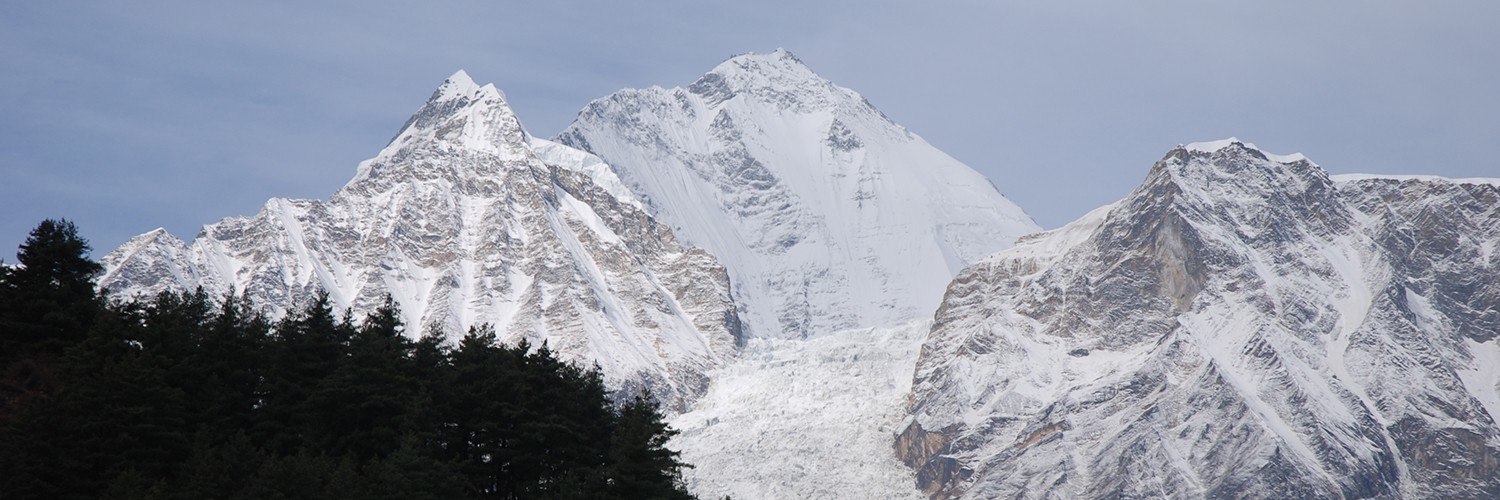
An early day begins as we make our way out of Tilicho Base Camp ascending towards the Tilicho Lake. With the views of Gangapurna (7,454m), Annapurna II (7,937m), Annapurna III (7,555m) and surrounding peaks, we make our way through the glacial moraines. At an altitude of 4,920m, the lake is the one situated at the highest altitude for its size. Boasting an unparalleled natural beauty and mesmerizing views of the Annapurna Range, the lake offers a lovely respite from the hectic journey. Enjoying the pleasant beauty of the lake we make our way back to Khangsar.
After a well-rested night at Khangsar, we head towards Yak Kharka. Deep into the Himalayas majority of the journey passes through complete solitude. From Khangsar, the trail steeply ascends before beginning the descent. After a brief rest at the bottom of the hill, we once again begin our ascending journey to reach Yak Kharka. The summer settlement is only occupied during summer and locals head down to warmer regions during winter.
One of the easier days of the trek, today, we head over to Thorung Phedi located at the edge of the Thorang La Pass (5416m). Heading out of Yak Kharka, we follow the Jarsang Khola for the entirety of the journey. Thorung Phedi is surrounded by vertical rock faces on all sides creating a natural valley. The settlement is a small one and like Yak Kharka many of the locals make their way down to warmer areas during winter.
An early day as we make our way out of Phedi headed towards the High Camp of Thorang La Pass (5416m). Located at an altitude of 4,925m, the High Camp is comprised of a single hotel. Navigating past the icy Himalayan trail this section of the journey takes us through the wilderness gradually ascending towards the summit. At an altitude of 5,416m Thorang La Pass is one of the biggest Himalayan passes across the globe. Additionally, it offers a mesmerizing view of the Himalayas in Annapurna and Nilgiri ranges. Enjoying the beauty of the Annapurna Himalayan Range from the summit, we begin our descending journey making our way towards Charabu before descending to Muktinath.
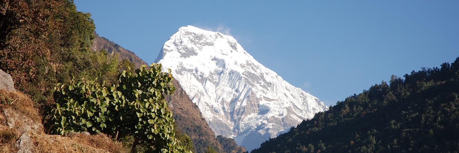
The day begins early as we head over to the Hindu temple of Muktinath enjoying the pleasant views of the arid valley down below. Meaning place of liberation the temple is considered to be one of the 108 premium temples by the Vaishnava Sect. Taking ample time to explore the temple as well as surrounding local markets, we begin our journey descending through the arid landscape prevalent throughout Mustang. Taking a brief rest at the hamlet of Kagbeni, we find the banks of Kali Gandaki River leading to the town of Jomsom.
One of the more challenging parts of the trek, today, we make our way towards Sikha. The journey begins with a short descent over to the Kali Gandaki River beyond which lies the Ghar Khola. Crossing both rivers on suspension bridges, we arrive at the base of the hill leading towards Sikha. The ascending climb is a steep one through the lush green forests as we head past small hamlets towards Sikha.
A short day awaits us as we exit the hamlet of Sikha making our way towards Ghorepani. The journey takes about 3 to 4 hours and is less steep than the one leading to Sikha. From Sikha, the trail once enters the rhododendron forests as we make our journey through the stone steps. After passing Chitre, we continue our journey accompanying the pack mules and horses. The hamlet of Ghorepani is marked by a large archway and a few houses.
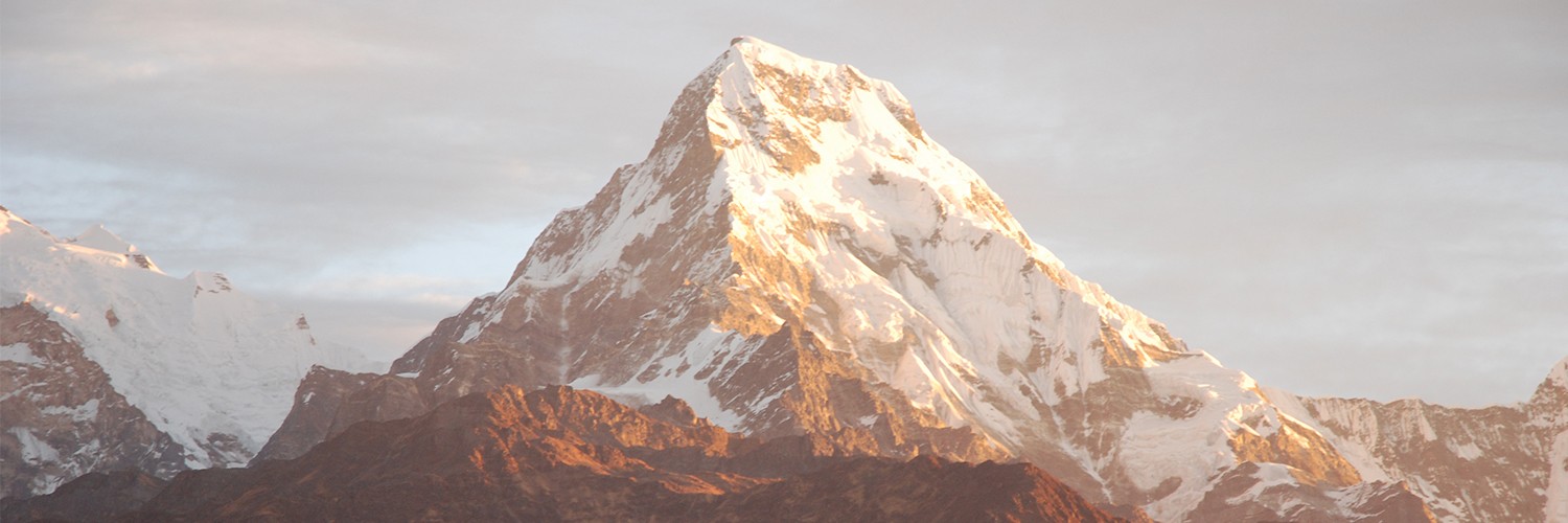
An early day as we make our way out of Ghorepani ascending towards the hill station of Poon Hill. Located at an altitude of 3210m, the viewpoint offers stunning Himalayan views at sunrise. Spread across the horizon are the prominent peaks of the Annapurna Range including Annapurna South (7,219m), Annapurna I (8,091m), Dhaulagiri (8,167m), Lamjung Himal (6,983m), and Machhapuchhre (6,997m). Enjoying the pleasant sunrise, we descend back to Ghorepani for lunch before heading back to Ulleri.
The final day of the trek today we make our way towards the stunning valley of Pokhara. Exiting Ulleri, we find the forested trail down to Nayapul. Boarding the vehicle from Nayapul, we drive back to Pokhara enjoying the rural hilly landscapes en route. Back at Pokhara, we head directly to the hotel freshening up from the days of the journey. After a brief rest, you are free to explore the Lakeside area and enjoying the pleasant evening by Phewa Lake.
A Cold Feet representative will accompany you to the airport to catch your returning flight. We hope to see you again soon!
Making our way out of Pokhara, the journey settles alongside the winding pathways of Prithvi Highway. With the Himalayas to our backs, the journey once again takes us alongside the pleasant hilly landscapes accompanied by the Trishuli River. Entering the capital city, we make our way directly to the hotel.
Our representatives will once again drop you back at Tribhuvan International Airport just in time for your flight back home. We hope you had a lovely time with us and we look forward to seeing you again.
| Departure Date | Price | Group | Seats |
|---|
The trip to the Annapurna region has 2 major routes. One starts from Pokhara and the other from Besisahar which completely depends upon the trekking package you choose. Treks like Annapurna Circuit Trek, Tilicho Lake Trek, and Thorung La Pass Trek starts from Besisahar. The route passes Chame and Pisang to reach Manang and then to the Thorung La pass (5416m). Afterward, the trail will go towards the holy temple of Muktinath and then to Jomsom, and finally heads back toward Pokhara.
Similarly, treks like Annapurna Base Camp Trek, Ghorepani Poonhill Trek, Khopra Ridge Trek, Upper Mustang and Mardi Himal Trek begin from Pokhara. All these treks have different trekking routes. Upper mustang trek starts from Pokhara and goes through Jomsom and then long drive or trek to Lo-Manthang.
Autumn (September to November) and spring (March to May) seasons are considered the most favorable time for going on Annapurna Region Trek. The skies are much clearer giving you the best possible views of Annapurna, Nilgiri, Lamjung Himal, and Dhaulagiri ranges. Also, during spring, one gets the opportunity to witness the beautiful view of hills that are being covered with beautiful wildflowers like Rhododendron. Due to these reasons, the trails can be pretty much crowded during this time of the year.
However, the climate and weather conditions can be very much unpredictable at high altitude, so it is better to be prepared for any kind of situation.
There is always a risk factor since you will be hiking above 3000m. Different people will react differently to altitude changes, regardless of the fitness level or experience in the mountains. Due to this, learning and understanding about Altitude Sickness or Acute Mountain Sickness (AMS) and its symptoms beforehand is a must. For low altitude treks like the Ghorepani Poonhill Trek, the chances of suffering from AMS is quite low. However, further moving up towards higher altitude like Thorung La Pass (5416 meters), the chances of suffering from it becomes extreme.
For learning and understanding about this illness, you can ask your local medical expert, research online, or attend various training. There’s also an option in which you can attend the high altitude sickness lecture in Manang that is organized by the Himalayan Rescue Association.
Majority of the guest houses and teahouses offer you free Wi-Fi and charging ports for free or for a small charge. However, in remote high altitude areas, Wi-Fi service might not always be available. In such cases, you can also use the different data packages provided by the Mobile Network Service Providers (NTC and Ncell). Therefore, getting a local Sim-card is a must for the trip.
Yes, you require an Annapurna Conservation Area Project (ACAP) Permit to trek in the Annapurna Region Treks. The cost of the ACAP permit fee is NRs. 2000 (approx. USD 20)for foreigners and NRs. 200 (approx. USD 2) for SAARC nationals. Along with that, you will need Trekker's Information Management System Card (TIMS) which will cost NRs 1000 (approx. USD 10) per individual. Both of these permits can be taken from Nepal Tourism Board located at Bhrikutimandap, Kathmandu. For more information head to the official website of Nepal Tourism Board at https://www.welcomenepal.com/plan-your-trip/tims-card.html.
The Annapurna region is one of the most diverse and popular trekking areas in Nepal. The region is famously known for the warm hospitality of Gurung people and the magnificent views of Annapurna massifs and other mountains like Dhaulagiri (8167m), Nilgiri (7061m), Lamjung Himal (6983m), and Machhapuchhre (6997m). Also, cultural diversity and local cuisine make this destination unique. Other than this the Annapurna region is basically known for its diversity in flora and fauna. Regarded as one of the best trek trails in Nepal Annapurna region is a must-visit destination if you are a trekking enthusiast.
Not finding it? Ask a question
Your email address will not be published. Required fields are marked *


